
Anúncios
Measuring land accurately is essential for property owners, farmers, surveyors, and developers seeking to understand boundaries, plan projects, and ensure legal compliance.


Whether you’re purchasing a new plot, dividing an estate, or planning agricultural activities, knowing how to measure land properly can save time, money, and prevent future disputes. Traditional methods have evolved significantly, and today’s technology offers innovative solutions that simplify the entire process.
From simple tape measures to advanced GPS applications, understanding the available tools and techniques empowers you to make informed decisions about your property. Let’s explore the most effective methods for measuring land accurately and efficiently. 📏
Understanding Land Measurement Basics
Before diving into specific techniques, it’s crucial to grasp the fundamental concepts of land measurement. Area calculation involves determining the two-dimensional space within defined boundaries, typically expressed in square feet, square meters, acres, or hectares.
The shape of your terrain significantly influences the measurement approach. Regular geometric shapes like rectangles and squares are straightforward to calculate using length multiplied by width. However, most land parcels feature irregular boundaries that require more sophisticated methods.
Topography also plays a vital role. Flat terrain allows for simpler measurement techniques, while sloped or uneven land demands adjustments to account for vertical variations. Understanding these basics helps you select the most appropriate measurement method for your specific situation.
Traditional Methods for Measuring Land
Historically, surveyors relied on physical tools and manual calculations to determine land area. These time-tested techniques remain relevant, especially for smaller plots or when technology isn’t accessible.
Using Measuring Tapes and Chains
The most basic approach involves using a measuring tape or surveyor’s chain to record the length of each boundary. For rectangular plots, simply multiply length by width. This method works best for small, regularly shaped areas with clear boundaries.
When working with larger distances, surveyor’s chains (traditionally 66 feet or 20 meters long) provide more practical solutions than standard tape measures. Multiple people may be needed to keep the chain taut and ensure accurate readings across long distances.
The Triangulation Technique
For irregular shapes, triangulation offers a clever solution. This method divides the land into multiple triangles, measures each triangle’s base and height, calculates individual areas, and then sums them together for the total area.
This technique proved invaluable before modern technology, allowing surveyors to accurately measure complex parcels using basic geometry. While time-consuming, triangulation remains remarkably accurate when executed properly.
Modern GPS Technology for Land Measurement 🛰️
Global Positioning System technology has revolutionized how we measure land. GPS-enabled devices and smartphones now provide precise location data that translates directly into area calculations with minimal physical effort.
GPS measurement works by recording coordinate points as you walk or mark the perimeter of your property. The device then connects these points and calculates the enclosed area automatically, accounting for irregular boundaries with ease.

Accuracy varies depending on several factors including satellite visibility, atmospheric conditions, and device quality. Consumer-grade GPS typically offers accuracy within 3-5 meters, while professional-grade equipment can achieve centimeter-level precision.
Advantages of GPS Land Measurement
GPS technology brings numerous benefits to land measurement projects. Speed stands out as a primary advantage—you can measure large properties in a fraction of the time required by traditional methods.
The digital nature of GPS measurements allows for easy data storage, sharing, and integration with mapping software. You can instantly visualize boundaries, export measurements to various formats, and maintain permanent records of your property dimensions.
GPS also excels at measuring irregularly shaped parcels where traditional geometry becomes cumbersome. The technology adapts seamlessly to curves, angles, and complex boundary configurations without requiring mathematical expertise.
Mobile Applications for Field Measurement 📱
Smartphone applications have democratized land measurement, putting professional-grade tools in everyone’s pocket. These apps leverage built-in GPS capabilities to deliver surprisingly accurate results without specialized equipment.
Most land measurement apps function similarly: you simply walk the perimeter of your property while the app records GPS coordinates at regular intervals. Once you complete the circuit, the application calculates total area, perimeter distance, and often provides additional features like waypoint marking and measurement history.
Key Features to Look For
When selecting a land measurement app, certain features enhance usability and accuracy. Real-time tracking displays your path as you walk, helping ensure you don’t miss sections or overlap unnecessarily.
Multiple unit support allows conversion between different measurement systems—crucial when working with international standards or specific regional requirements. Look for apps offering square feet, acres, square meters, hectares, and other common units.
Export capabilities enable you to share measurements with contractors, buyers, or authorities in various formats including PDF reports, KML files for Google Earth, or direct sharing via email and messaging platforms.
Accuracy Considerations
While convenient, smartphone-based measurements have limitations. GPS accuracy depends on clear sky visibility, so dense tree cover or urban canyons may reduce precision. Taking measurements on clear days in open areas yields the best results.
Most quality apps include accuracy indicators that show the current GPS precision level. Pay attention to these readings and consider re-measuring if accuracy falls below acceptable thresholds for your purpose.
For legal boundary determinations or property transactions, professional surveys remain the gold standard. Mobile apps serve excellently for planning, estimation, and informal measurements, but shouldn’t replace certified surveys when legal documentation is required.
Professional Surveying Methods
When precision is paramount—such as for legal documentation, construction planning, or property disputes—professional land surveyors employ advanced equipment and methodologies that deliver exceptional accuracy.
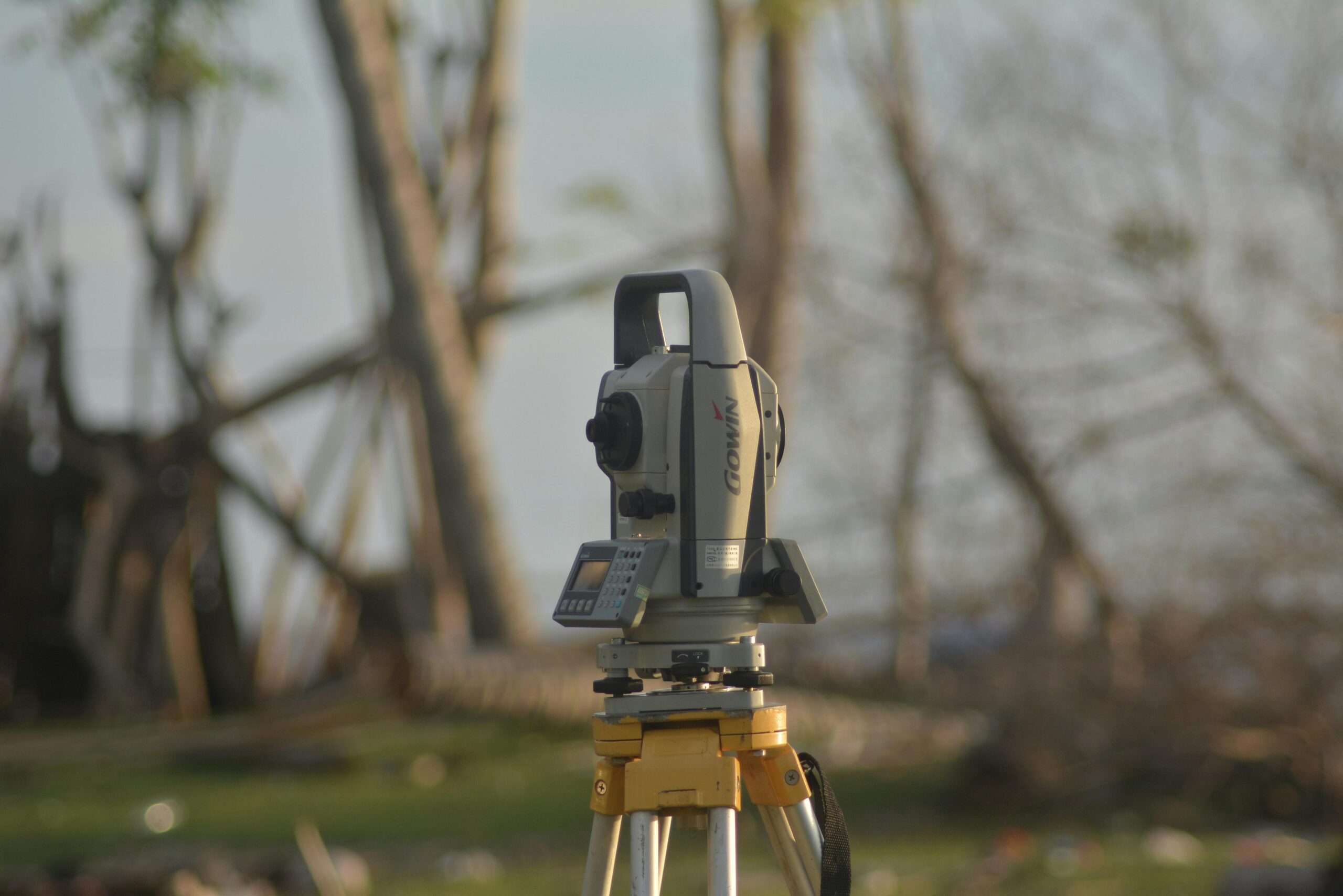
Total Station Technology
Total stations combine electronic theodolites with distance measuring equipment to calculate coordinates with millimeter precision. These sophisticated instruments measure angles and distances simultaneously, creating highly accurate three-dimensional mapping of terrain.
Licensed surveyors use total stations to establish official property boundaries, create topographic maps, and provide legally binding documentation of land dimensions. The process involves setting up the instrument at known reference points and systematically measuring to boundary markers.
Differential GPS (DGPS)
Professional-grade GPS systems use differential correction techniques that achieve centimeter-level accuracy. DGPS employs reference stations with known locations to calculate correction factors, dramatically improving standard GPS precision.
This technology proves invaluable for large agricultural operations, mining projects, and infrastructure development where both high accuracy and efficient coverage of extensive areas are necessary.
Calculating Area for Different Land Shapes
Understanding basic geometry helps you verify measurements and estimate areas quickly. Different land shapes require specific formulas for accurate calculation.
Regular Geometric Shapes
For rectangular or square plots, the calculation couldn’t be simpler: multiply length by width. A plot measuring 100 feet by 150 feet equals 15,000 square feet, or approximately 0.34 acres.
Triangular parcels use the formula: area = (base × height) ÷ 2. Measure the length of one side as the base, then measure the perpendicular distance from that side to the opposite corner for the height.
Circular or semi-circular areas use the formula: area = π × radius². For a circular plot with a 50-meter radius, the area would be approximately 7,854 square meters or 1.94 acres.
Irregular Parcels
Most real-world land parcels don’t conform to perfect geometric shapes. For these, you have several options: divide the area into smaller regular shapes, use triangulation, or employ coordinate-based calculations.
The coordinate method involves recording the GPS coordinates of each corner point, then applying mathematical formulas (like the Shoelace formula) to calculate the total enclosed area. Modern apps and software handle these complex calculations automatically.
Common Measurement Units Explained 📐
Land measurement uses various units depending on location, tradition, and purpose. Understanding these helps you interpret measurements correctly and convert between systems when necessary.
| Unit | Equivalent | Common Use |
|---|---|---|
| Square Foot | 0.093 square meters | Small plots (US) |
| Acre | 43,560 square feet | Medium properties (US/UK) |
| Hectare | 10,000 square meters | Agricultural land (metric) |
| Square Meter | 10.76 square feet | International standard |
In the United States, acres remain the standard for larger properties, while square feet describe smaller lots. One acre equals approximately 208.7 feet per side if perfectly square, though actual parcels rarely have such regular dimensions.
The metric system uses square meters for smaller areas and hectares for larger properties. One hectare equals 2.47 acres, making conversion between systems relatively straightforward with modern calculators or apps.
Practical Tips for Accurate Measurements ✅
Regardless of which method you choose, following best practices ensures the most accurate results possible. Preparation and attention to detail make significant differences in measurement quality.
Before You Measure
Identify all boundary markers before beginning. These might include stakes, monuments, fences, or natural features mentioned in property deeds. Clear vegetation or obstacles that might interfere with sight lines or GPS signals.
Check weather conditions when using GPS-based methods. Overcast skies or active storms can interfere with satellite signals, reducing accuracy. Clear, dry conditions provide optimal measurement environments.
Charge devices fully and bring backup power sources for longer measurement sessions. Running out of battery mid-measurement means starting over and potentially getting inconsistent results.
During Measurement
Walk slowly and steadily along boundaries when using GPS methods. Rapid movements or erratic paths introduce errors into coordinate recording. Maintain a consistent pace and follow the actual boundary as closely as possible.
Take multiple measurements when precision matters. Measure the same parcel two or three times and compare results. Significant variations indicate potential issues requiring investigation.
Document everything with photos and notes. Capture images of boundary markers, unique features, and reference points. These records prove invaluable when questions arise later or when communicating with others about the property.
Legal and Practical Considerations
Understanding when informal measurements suffice versus when professional surveys are necessary protects your interests and ensures compliance with legal requirements.
When Professional Surveys Are Required
Property transactions almost always require certified surveys conducted by licensed professionals. Lenders, title companies, and local authorities typically won’t accept informal measurements for legal documentation.
Boundary disputes necessitate professional involvement. If disagreements arise with neighbors regarding property lines, only certified surveys carry weight in legal proceedings or mediation.
Construction permits often require professional site plans showing accurate property dimensions, setbacks, and easements. Building departments need certified information to verify compliance with zoning regulations.
When Informal Measurements Work Well
Planning and estimation projects don’t require professional precision. If you’re calculating fertilizer needs, planning irrigation systems, or estimating construction materials, GPS apps provide sufficient accuracy.
Personal record-keeping benefits from regular informal measurements. Tracking property dimensions over time, monitoring encroachments, or documenting land use patterns all work well with consumer-grade tools.
Preliminary assessments before purchasing property help you evaluate whether a parcel meets your needs. While you’ll need professional surveys before closing, initial measurements guide your decision-making process.
Maximizing Accuracy with Modern Tools 🎯
Technology continues advancing, offering increasingly sophisticated yet user-friendly tools for land measurement. Understanding how to leverage these innovations delivers professional-quality results.
Combining multiple methods provides verification and confidence. Use GPS measurements for overall area, then spot-check critical dimensions with physical measurements. This hybrid approach catches errors and confirms accuracy.
Calibration matters for all electronic tools. Some GPS apps allow manual accuracy adjustments based on known reference points. Taking time to calibrate against surveyed markers significantly improves results.
Cloud storage and synchronization protect your measurement data. Modern apps automatically back up measurements to cloud services, preventing data loss and enabling access from multiple devices.
Measuring Sloped or Uneven Terrain
Hills, valleys, and irregular topography complicate land measurement. Standard area calculations assume flat surfaces, so slopes require special consideration for accurate results.
The difference between surface area and horizontal projection becomes significant on steep slopes. A hillside might have 20% more surface area than its horizontal projection suggests. Professional surveys account for these variations when precision matters.
GPS measurements typically calculate horizontal area automatically, which works well for most purposes. However, if you need actual surface area—for example, calculating material coverage—additional topographic data becomes necessary.
Contour mapping apps and tools help visualize elevation changes and calculate true surface areas. These specialized applications use elevation data from satellite sources or manual measurements to create three-dimensional terrain models.
Cost Considerations for Different Methods 💰
Budget often influences which measurement method you choose. Understanding the cost spectrum helps you make informed decisions balancing accuracy needs against available resources.
Professional surveys represent the highest cost option, typically ranging from several hundred to several thousand dollars depending on property size, complexity, and location. However, they provide legally defensible accuracy and comprehensive documentation.
Consumer GPS devices designed specifically for land measurement cost between $100-$500, offering good accuracy without recurring fees. These handheld units often provide better precision than smartphones in challenging environments.
Smartphone applications represent the most economical option, with many quality apps available for free or under $20. For informal measurements and planning purposes, these deliver excellent value and surprising accuracy.
Future Trends in Land Measurement Technology
Emerging technologies promise even greater accessibility and precision for land measurement. Staying informed about these developments helps you leverage new capabilities as they become available.
Drone-based measurement systems are becoming more affordable and user-friendly. These aerial platforms capture high-resolution imagery and create precise topographic models, combining the accuracy of professional surveys with the convenience of DIY solutions.
Augmented reality features are beginning to appear in measurement apps, overlaying property boundaries and dimensions onto real-world camera views. This visualization helps property owners understand spatial relationships more intuitively.
Artificial intelligence integration improves accuracy by detecting and correcting GPS errors, automatically identifying boundary features, and suggesting optimal measurement paths based on terrain and satellite visibility.
Measuring land accurately empowers property owners with essential knowledge about their assets. Whether you choose traditional methods, modern GPS technology, or professional surveying services, understanding the options and their appropriate applications ensures you get reliable results suited to your specific needs. The tools available today make accurate land measurement more accessible than ever, transforming what was once a specialist skill into something any property owner can accomplish with confidence. 🌍